21/00552/FUL Solar Farm and battery stations together with all associated works, equipment and necessary infrastructure
Bunkers Hill Farm, Reading Road, Rotherwick, Hook, Hampshire RG27 9DA
Overview
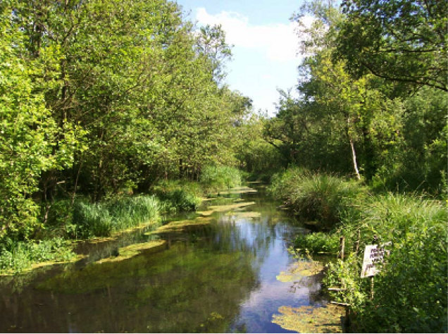
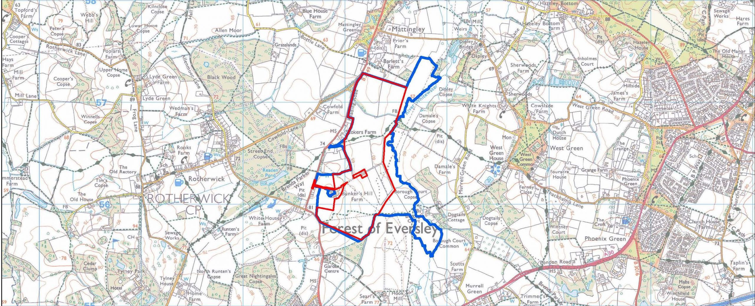
JBM Solar is proposing a photovoltaic solar farm on land at Bunkers Hill Farm. The proposal would cover approximately 200 acres of Grade 3b agricultural land and deliver up to 50MW renewable energy. The site runs alongside the River Whitewater, with solar panels for the next 35+ years. We encourage you to look at the developer’s website to see the location of this proposal, also shown on the map above.
This is one of four current proposals for large solar farms in the Whitewater Valley, and one of five in very close proximity in the vicinity of Hook, North-East Hampshire, all of similar size and capacity. Each of these three proposals is just below 50MW, because over that capacity, they would be designated as nationally significant infrastructure, which would require consent of the appropriate Secretary of State.
The site proposed is:
- Green belt (currently grade 3b farmland) of approximately 71 Ha
- The site is within the parish of Rotherwick and the location impacts the parishes of Mattingley, Hook and Hartley Wintney
- The location is bounded approximately by Bartlett’s Farm to Hook allotments (North to South) and the B3349 to River Whitewater (West to East).
Landscape character and type
The Bunker’s Hill proposed development is located on a greenfield site, on the western valley sides of the Whitewater Valley, on gently undulating land.
As noted in Hart’s report on the EIA screening (20/01807/EIA) the site is within the Whitewater Valley Landscape Character Area. This proposal would introduce built development on a greenfield site over a significant area. The proposed development would change the visual appearance of the area and result in some impact upon the landscape.
Hart’s Landscape Character Assessment (1997) identifies the Whitewater Valley landscape character area as within the Open Arable Farmland landscape type. Hampshire’s Integrated Landscape character assessment (2010) classifies the site as falling within Lower Mosaic Open landscape type.
Rights of way
The site has a sloping topography and is part of the valley for the River Whitewater with varying degrees of visibility from Reading Road. There are three public rights of way (PRoW) that cross the site:
- PRoW16 running north/south through the northern part of the site then past Barlett’s Farm;
- PRoW17 running east/west through the central part of the site past Neville’s; and
- PRoW23 running east/west across the southern part of the site south of Bunkers Hill Farm.
In particular, the Brenda Parker Way long distance route runs between Andover and Aldershot. This route connects Tylney Park with the river valley and West Green Conservation Area in the east.
Other footpaths provide circular routes from centres of population into and across the Whitewater Valley landscape.
The use and value of these routes increased dramatically in 2020-21 and has remained high with many residents now working from home.
Landscape and visual impact
Landscape impacts may be confined to the site, whilst visual impacts would be wider. Coverage of the site would be over a large area but at low level. These impacts would be reduced through the retention of landscape features such as trees and hedges, although any such mitigation measures would likely vary in effectiveness given seasonal changes in foliage.
Therefore it is important o fully assess impacts on landscape and visual amenity through a comprehensive Landscape and Visual Impact Assessment, particularly in relation to public views from the PRoWs.
Local communities value the recreational resource, which the river and valley provides. So it will be important that the Landscape and Visual Impact Assessment (LVIA) provides a comprehensive set of representative viewpoints. These include assessment of effects from other key features, such as heritage and nature conservation assets, particularly where they contribute to sense of place and special qualities of the river and landscape more widely.
The proposed development includes a number of features, which can give rise to landscape and visual effects, in addition to the photovoltaic arrays. Ancillary development, such as fencing and CCTV posts, can also have an urbanising influence on the landscape.
Deer fencing in an area heavily populated by deer and in a council named after the deer (Hart) is of particular concern.
The current proposed layout does not detail the position of inverters (other than the central inverter), CCTV poles, storage container(s), access arrangements, delivery station or the location of the construction compound.
We would expect the LVIA to consider the effects of all aspects of the proposed development. This includes during construction, operation and in relation to the potential for solar glare.
Local plan
Local Plan Policy NBE2 – Landscape is relevant to the proposed application. It states that ‘development must respect and wherever possible enhance the special characteristics, value and visual amenity of the District’s landscapes. This should be done with reference to the Hart District Landscape Character Assessment, visual amenity and scenic quality of the landscape and other identified criteria.’
There is increased recognition of the value of landscapes in terms of Local Plan Policy, local communities (as reflected in the Hook Neighbourhood Plan) and National Planning Policy (Para 170). Given this, we request that the LVIA includes a detailed assessment of landscape value of the Whitewater Valley, which will be affected by the proposed development.
Whitewater Valley Preservation Society response
The Whitewater Valley Preservation Society submitted its WVPS comments re Bunkers Hill Solar Farm objection to Hart District Council on the full application for a solar Farm at Bunkers Hill, Rotherwick, Hook RG27 9DA.
Our analysis of the application revealed that the applicant has failed to meet the pre-application advice provided. The applicant failed to provide thorough, rigorous assessments of the effects on Landscape, Public Rights of Way (PRoW), Heritage Assets and Ecological impact.
The Society’s thorough reviews of the developer’s assessments reveals the true extent of damage that would be caused by this proposal. The reviews also demonstrate that the application fails to comply with Hart’s policy requirements and, therefore, fails to satisfy the basis on which the application could be approved.
In conclusion, the Society believes this development would have a significantly negative impact on the Whitewater Valley. The development would destroy the valued landscape and historic assets / environment of the Whitewater Valley. This development – if approved – would change the rural nature of the Whitewater Valley and adversely affect the enjoyment of its landscape by this and future generations.
The Society’s members believe passionately in the integrity of this beautiful section of the Valley. They are distraught at the damage that would be caused to this idyllic and characteristic lowland river valley by what would be an extremely industrial intrusion of the proposed solar farm and its accompanying paraphernalia.
It is on this basis that the Whitewater Valley Preservation Society objects to the application. We therefore trust that Hart will refuse this application.
Background to the proposal
- The full planning application – 21/00552/FUL Solar Farm and battery stations together with all associated works, equipment and necessary infrastructure – was registered on 8 March 2021. To view the application documents and submit your comments, please go online to Hart District Council planning applications , click on “View and comment on planning applications“, and enter 21/00552/FUL in the Search box. The deadline to submit comments to the public consultation was Wednesday, 7th April 2021.
- JBM Solar conducted a limited consultation on their initial proposals in September 2020. This was publicised by posting leaflets to selected addresses in the Rotherwick area; and initially requested responses from residents within a few weeks. The Whitewater Valley Preservation Society requested that their publicity was extended to a much more appropriate, wider area and an extension to their deadline to Friday, 23rd October 2020. We submitted our response by the extended deadline. To request a full copy of our response, please email us.
- A request for screening opinion – 20/01807/EIA – as to whether the solar farm planning application would require a full Environmental Impact Assessment, was submitted on 3 August 2020. Whilst a full EIA was not required, the report noted that:
- Potential impacts on the River Whitewater (including those from accidents) would need to be fully assessed
- Given the site area, flood risk zones and that the land immediately adjacent to the river such that the ground is at risk of groundwater flooding, any planning application would require a Flood Risk Assessment and drainage strategy.
- There may be impacts upon the settings of heritage assets nearby. These include the Mattingley Green and Rotherwick conservation areas and a number of (Grade II and one II*) listed buildings in close proximity to the site boundary. Such impacts would need be considered in a Heritage Assessment.

