Lodge Farm Warehouses and Logistics Centre Location Map
The Whitewater Valley Preservation Society has responded to a request for an Environmental Impact Assessment Scoping opinion in relation to development proposals of 32 hectares of agricultural land at Lodge Farm, North Warnborough (22/01347/EIA).
WVPS points to serious environmental impacts on the River Whitewater, a chalk stream which is already failing to achieve Good Ecological Status, including:
flooding risk as the development proposal is in the floodplain of the River Whitewater
the impact on an already water stressed area, which will change significantly when water abstraction from the River Whitewater ceases in May 2023
sewage capacity in a system that is already over capacity leading to sewage overspills into the River Whitewater
In addition WVPS points to the devastating visual impact in a currently open agricultural landscape, which is crossed by several public rights of way (footpaths) connecting the many surrounding Conservation Areas and Sites of Special Scientific Interest (SSSIs).
The application fails to mention the nationally recognised colonies or rare bat species located in the Greywell Tunnel, which use the River Whitewater and Basingstoke Canal for their navigation and feeding routes. The application therefore needs lighting to be considered in the scope of the environmental impact assessment.
WVPS has therefore requested that the scope of the Environmental Impact Assessment is extended to include surface water management, sewage and lighting.
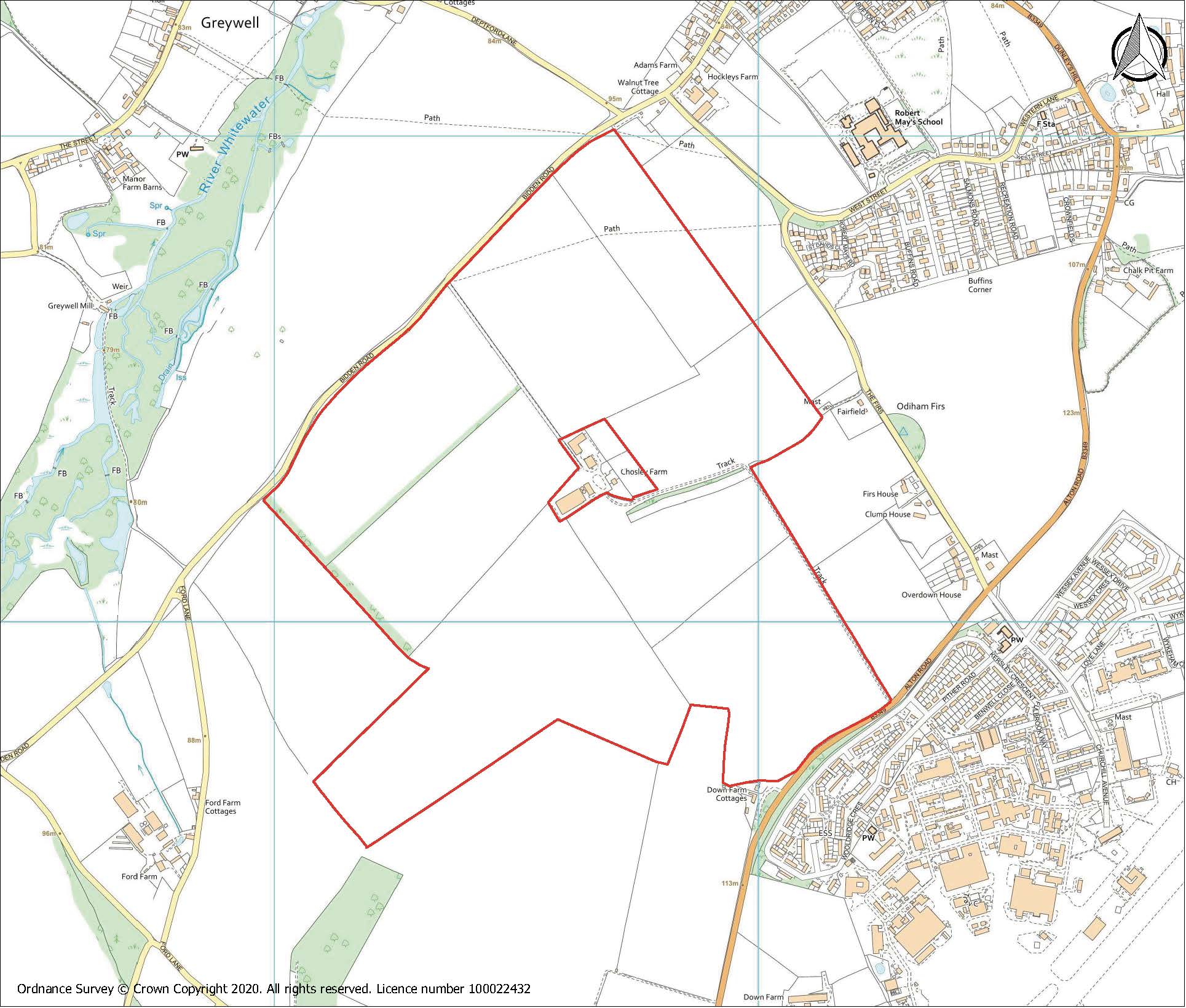
20/031835/FUL Chosley Farm Solar Park, Bidden Road, North Warnborough Whitewater Valley Preservation Society response
Introduction
The Whitewater Valley Preservation Society was formed in 1980 with the specific aim of fighting unacceptable development proposals which founder members felt posed a significant threat to the health of the valley and the river.
The Society has set itself the objective of trying to protect the Whitewater Valley and the river from its source at Bidden to its confluence with the Blackwater, representing approximately nine miles of chalk stream. We represent some 200 riparian owners, residents and supporters of the Valley.
WVPS Objection
The National Planning Policy Framework (NPPF) paragraph 170b requires the classification of the agricultural land to be considered. NPPF clearly identifies the unsuitability of agricultural land that is higher than 3b for the siting for a solar farm. The Agricultural Quality Survey shows that the Chosley Farm proposal is on high quality agricultural land, with 51% categorised as Grade 3a, the “best and most versatile” agricultural land, which should not be prioritised for this development. If one considers the situation from an ecosystems services and natural capital assessment this site will surely fail.
HLP32 policy NBE2 states clearly that any adverse impact upon landscape and scenic quality and visual amenity must guide any principles of development.
The following assessment identifies the true extent of the impact upon all of these issues and one must not forget that the pre application advice stated that landscape was the key to whether this application could be approved or refused.
The applicant incorrectly claims that the chosen site is ideal with its dome shape because they consider that gives the site limited visibility. Whereas landscape features, landscape character and visual affects are all detrimentally impacted as a result of choosing a site located only a few metres from the well-known signal station site The Firs.
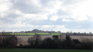
As a consequence not only will the significance of the Firs be degraded by the proximity of 95.47 Ha of dark reflective material and superstructure together with 3m hedging. The applicant’s own material indicates the 360° angle from which the site will be viewed from adjacent roads, major and minor, footpaths and bridleways but ignores the fact that due to the topography of the site it is visible for miles around and sufficiently far afield to be easily visible from such villages as Greywell, South Warnborough, and Upton Grey.
The site is adjacent to the SSSI at Greywell Fen and the northern half of the site is contained within the upper slopes of the Whitewater Valley, in one of the few places along the length of the river where the valley is pronounced and a visible and important part of the landscape. The photographs in below demonstrate that the longer range views and the landscape character will all be afflicted and adversely affected by the presence of the dark reflective panels and the way that the long views beyond the valley will be hidden by the proposed high planting needed to obscure the view of the solar farm, which will change the character of the landscape. The photographs illustrate clearly that the attempt by the applicant to claim that the landscape around this site has already been degraded by the RAF station is inaccurate, which in fact is invisible apart from the odd aerial, whereas the urbanising effect of the proposed installation will utterly destroy this altogether rural landscape.
From Greywell footpath above the village and just below Butter Wood
Landscape character
The main distinguishing features in the National Character Area profile are “the rolling elevated chalk arable downland has an open, exposed character that provides open skies and long-distance views” and in the Hart District Character Area assessment “typical chalk scenery with strongly rolling land forms, sooth hill tops and dry valleys. A dominance of intensive arable cultivation and weak hedgerow structure, shallower slopes at the edge of the chalk which creates a large-scale, predominantly open landscape with extensive views and a sense of exposure.”
The applicant claims the proposal would have a Neutral or Minor Beneficial impact on a landscape which is described as having weak hedgerow structure by planting very high hedges which will obscure the long views for which this landscape is recognised. There must be a question of confidence that a new chalk grassland can be achieved, given the proposed structures on site and management regime. Therefore the impact upon the landscape character must be regarded as Adverse.
Visual impact
A detailed assessment of the total visual effect upon the North Downs can only conclude a sufficiently adverse impact as to require, on its own, that the application be refused. Whilst the applicant claims to be able to turn Major and Moderate Adverse into Negligible Adverse or Neutral this is achieved by ignoring the 360° visual impact upon the landscape which will be viewed from the many roads, byways and public rights of way and in particular will impact upon the valley identified in the Hart District Landscape Assessment. Just downstream of the source at Bidden, the valley at Greywell is at its most discernible and should not be disrupted by the solid black and reflective insertion of 95.47 Ha of solar panels. Furthermore raising one’s eyes from the view across the valley (for example from many points in Greywell) the RAF station is nowhere to be seen, but the distant hills to the south reveal the extent of the long views and why the North Downs are so valued.
River Whitewater / Greywell Fen SSSI
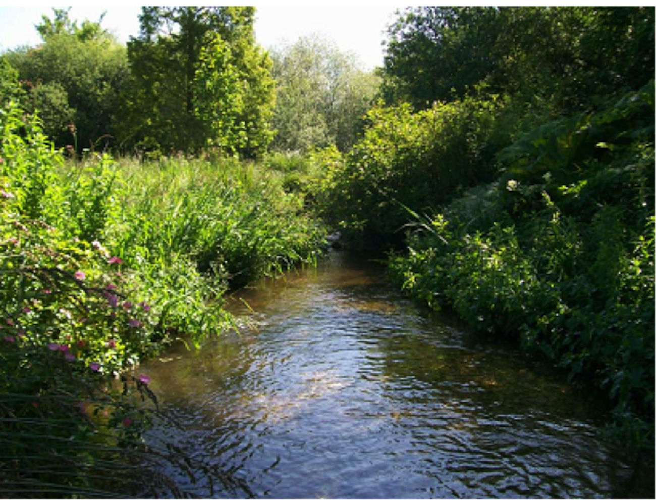
The proposed site is in the Whitewater Valley running right up to the source of the river Whitewater at Bidden Farm. The River Whitewater is a rare and important chalkstream environment, one of only around 200 hundred chalk streams globally, which combined with its proximity to the Greywell Fen SSSI, makes the location particularly inappropriate.
Greywell Fen is Grade 1 SSSI (Nature Conservation Review, NCR site). The main part of the site consists of waterlogged alkaline peats, flanked by a chalk valley. It has large areas of grazed fen meadow and tall fen vegetation, including reed beds.
According to the findings of the Environment Agency, the River Whitewater is currently failing to meet ‘Good Ecological Status’ as required under the Water Framework Directive. This conclusion is supported by three years of Riverfly surveys commissioned by the Whitewater Valley Preservation Society, with Salmon & Trout Conservation.
Natural England considers that the application could have potential significant effects on the Greywell Fen SSSI, particularly through construction impacts (e.g. from dust, spillages, polluted runoff etc) and discharges to the protected fen, wetland and river habitats.
In order to mitigate these adverse effects and make the development acceptable, Natural England requires that a drainage design should be submitted and agreed with Hart District Council. This should include evidence to show that the proposals will ensure there will be no deterioration in water quality, or changes to water quantity, in discharges from the site. This has not been provided with the application.
Basingstoke Canal SSSI
The Basingstoke Canal, together with associated ‘flashes’ and heathland, is nationally important for aquatic plants and invertebrates. The transition from calcareous spring water to slightly acidic conditions produces an extremely diverse flora, containing approximately half (87) of Britain’s native aquatic higher plant species, including 5 nationally scarce species. The Basingstoke Canal is botanically the most species-rich aquatic system in England. Twenty-four species of dragonfly occur on the Canal and other insects, including two nationally rare (Red Data Book) species, are well represented. Two sections of the Basingstoke Canal are of SSSI status. The western section lies between Greywell in Hampshire and Hermitage Bridge in Surrey.
The relative lack of pollution in the canal and the variation in water chemistry throughout its length have given rise to a diversity of plant species and communities that has no parallel elsewhere in Britain. This together with a rich and varied invertebrate fauna makes Basingstoke now a waterway of exceptional value to nature conservation:
The canal is largely supplied by calcerous water from Springs situated at the junction of the chalk and Reading beds (clay) at Greywell. Due to a slight West-East gradient, which gives rise to a definitive water movement, the overall system is an analogous to a slow flowing River with initially alkaline water which gradually becomes more acidic and less charged with calcium. Such a combination is a rare feature in Britain.
The vegetation types reflect this gradual change in water chemistry. At Greywell the flora is typical of that of a nutrient-rich southern chalk stream.
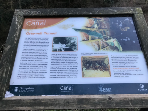
Greywell Tunnel information board
The Greywell Tunnel is of huge ecological importance as a haven for bats. The blockage has created a cave like environment within the tunnel, a constant temperature around 10°C and a high humidity provide excellent conditions for hibernating bats.
During the winter months it supports the second largest hibernating population of Natterer’s bat in Europe. Five bat species have been recorded in hibernation within the tunnel – Natterer’s (Myotis nattereri), Daubenton’s (Myotis mystacinus), Whiskered (Myotis mystacinus) and Brown long-eared (Plecotus auratus).
Large congregations of bats have been recorded swarming at both East and West portals of the tunnel during the autumn months. This behaviour has been observed at other important bat hibernation sites and is believed to be associated with mating. It has been found that bats come to such sites from great distances – radius of 60km or more. The genetic mixing as a result of mating between individuals from over such a large area helps keep bat populations healthy. During swarming studies the rare Bechstein’s (Myotis bechsteinii) and Barbastelle (Barbastella barbastellus) bats have been recorded visiting Greywell tunnel.
Natural England have commented that there is particular potential for adverse effects on the Greywell Tunnel (Basingstoke Canal) SSSI as the development would potentially impact on commuting and foraging routes for bat species utilising the tunnel for roosting. This comment was made elsewhere (Natural England review[i] of evidence of the impact of solar farms on birds, bats and general ecology and the EIA screening for the solar farm at Long Sutton) – but not on this application, which is much nearer and in the same valley as the Basingstoke Canal at Greywell Tunnel.
The Biodiversity Net Gain report produced by Weddle Landscape Design is misleading as it refers only to the claimed biodiversity “net gain” calculated via Natural England’s much criticised algorithm[ii]on the site itself. As outlined above, the important SSSIs of Greywell Fen, Basingstoke Canal and the River Whitewater are where the biodiversity and ecological impacts of this proposal will be felt.
Flood Risk Assessment / Drainage strategy
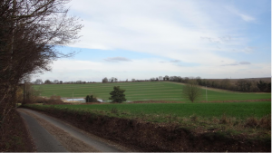
The Flood and Water Management team of Hampshire County Council, as the Lead Local Flood Authority, points out that the application contains no information about the proposed impermeable areas, discharge rates and volumes, so it fails to describe the real impact of the development on surface water management and local flood risk.
The picture below shows the almost permanently present “pond” opposite Ford Farm, showing where surface water drains off the solar farm site across Bidden Road and flows into the River Whitewater at/near its source. The presence of a major surface water overland flow route crossing the site and the need to robustly assess this as part of any future planning application is noted in the EIA screening.
Natural England states that drainage from the site could lead to deterioration in water quality, changes to water quantity in discharges from the site. Given that both the River Whitewater and the Basingstoke Canal SSSIs are designated for their unique water quality and chemistry this implies that surface water discharge could impact on these protected features.
The almost permanent pond opposite Ford Farm
Archaeology
Chosley Farm is the site of an important Romano British archaeological site as identified by the below ground archaeological section of the submitted Heritage Desk Based Assessment. The assessment demonstrates that there are a number of archaeological sites within the application area and that the site has a high potential to contain as yet unrecorded archaeological sites for the prehistoric periods through to the Roman period.
The impacts of the development such as roads, compounds, fencing and service trenches will have an archaeological effect (para 4.19). The assessment suggests that a staged approach to the mitigation is appropriate from targeted preliminary survey to mitigation, including mitigation by avoidance (ie preservation insitu) (para 5.7 to 5.11).
Application Process & Content
Hart District Council, as the Local Planning Authority, decided that an EIA was not required for this development, whereas they have decided that an EIA is required for a very similar size and scale of proposed solar farm development nearby to the south side of RAF Odiham.
There are inconsistencies between the submissions of consultees and opinions on whether an EIA is required, detailed in the Appendix 2, concluding:
20/01658/EIA Chosley Farm, North Warnborough
20/02632/EIA Ford Farm, Long Sutton
Location
The site is not environmentally sensitive such that significant environmental impacts are anticipated.
The site is therefore considered to be environmentally sensitive such that significant environmental impacts cannot be ruled out.
Types and Characteristics of the Potential Impacts
The characteristics of the proposed development are not such that significant environmental impacts are anticipated.
The characteristics of the potential impact, given the spatial extent of the development, the nature of the impact in visual terms, the certainty of the impact and the duration of the impact (a minimum of 40 years), are such that significant environmental impacts are anticipated.
The Planning Design & Access Statement provided by the Applicant is incorrect in a number of ways, including:
It identifies the River Whitewater as the River Blackwater, which is 11 miles away.
It identifies the Greywell Fen SSSI but fails to identify the Basingstoke Canal SSSI or the SSSIs that exist along the River Whitewater, which is also a SINC for its entire length.
This has a domino effect of errors and omissions on material impacts throughout the application and consultation, such that Natural England’s advice and the Applicant’s Landscape & Ecological Plan are incorrect and incomplete. These identify the Greywell Fen SSSI but fails to identify the Basingstoke Canal SSSI or the SSSIs that exist along the River Whitewater.
Summary
The landscape and visual impact, the ecological and water quality impact on SSSI protected sites and the archeological importance of the site combined provide reason to avoid irreversible land use change on this site.
For all of the reasons in the foregoing, WVPS wishes to register the strongest possible objection to this application and requests that it be refused.
The Whitewater Valley Preservation Society has submitted its latest response to amended information submitted by the potential developer of Chosley Farm Solar Park, Bidden Road, North Warnborough. Please find this here: Chosley Farm amendments objection.
21/00552/FUL Solar Farm and battery stations together with all associated works, equipment and necessary infrastructure
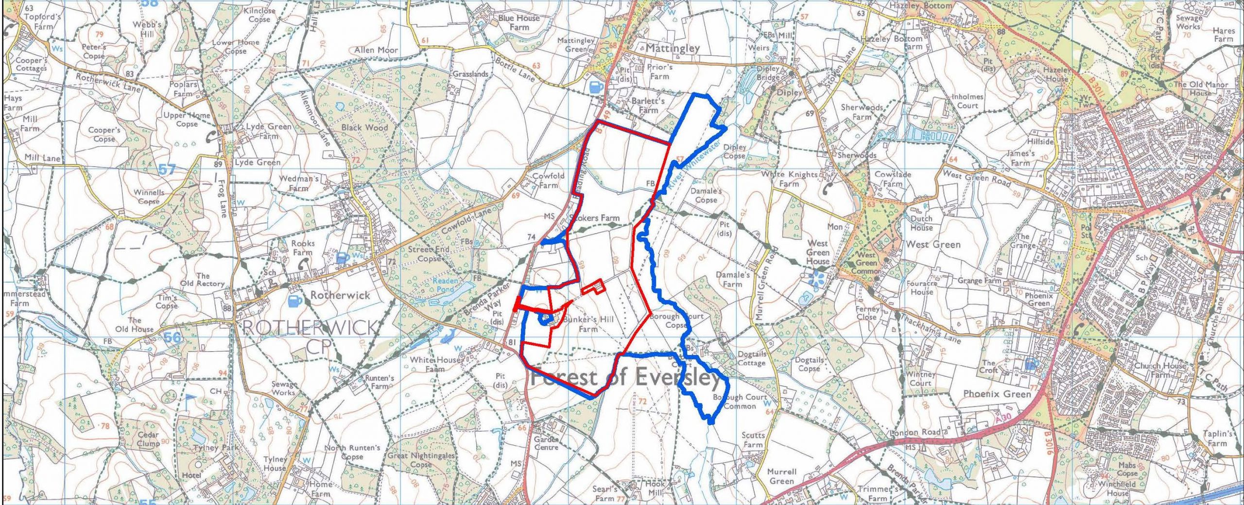
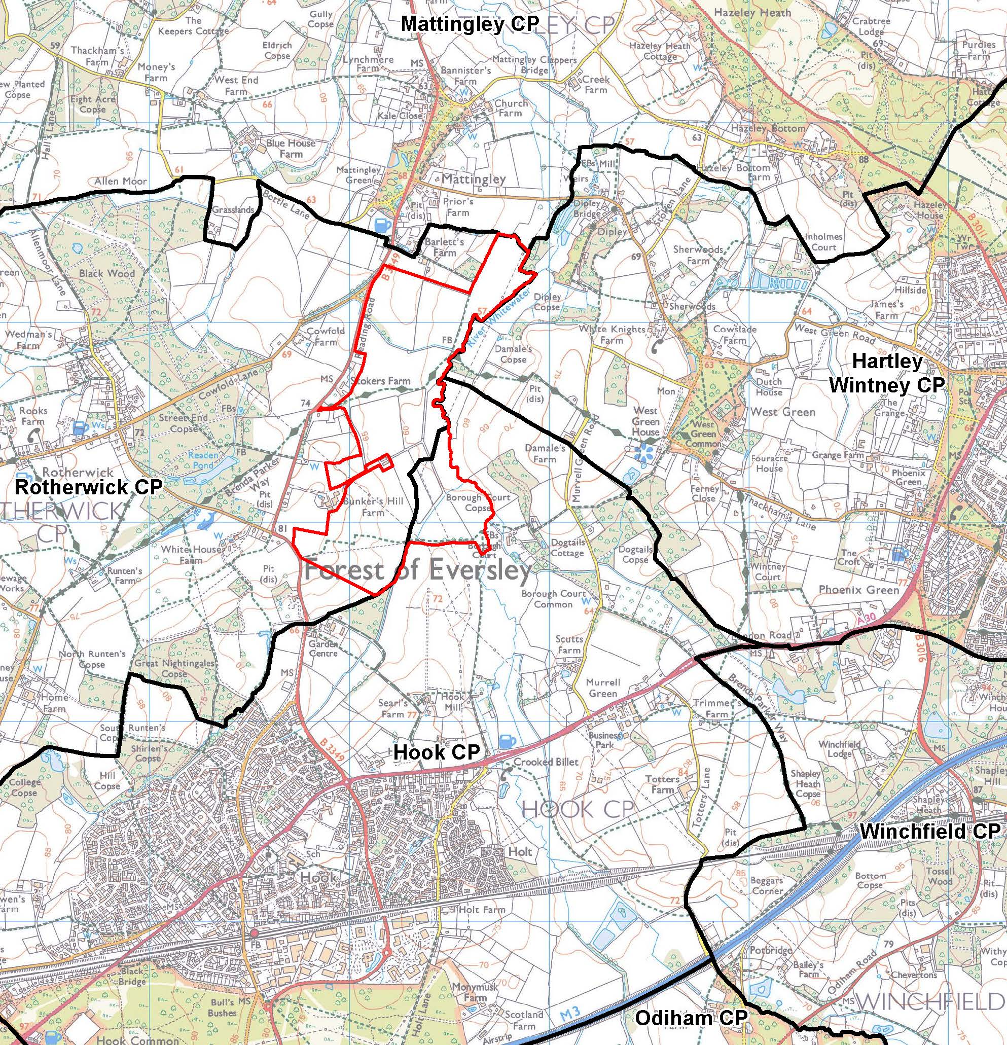
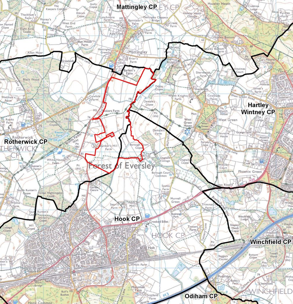
Bunkers Hill Farm, Reading Road, Rotherwick, Hook, Hampshire RG27 9DA
Overview
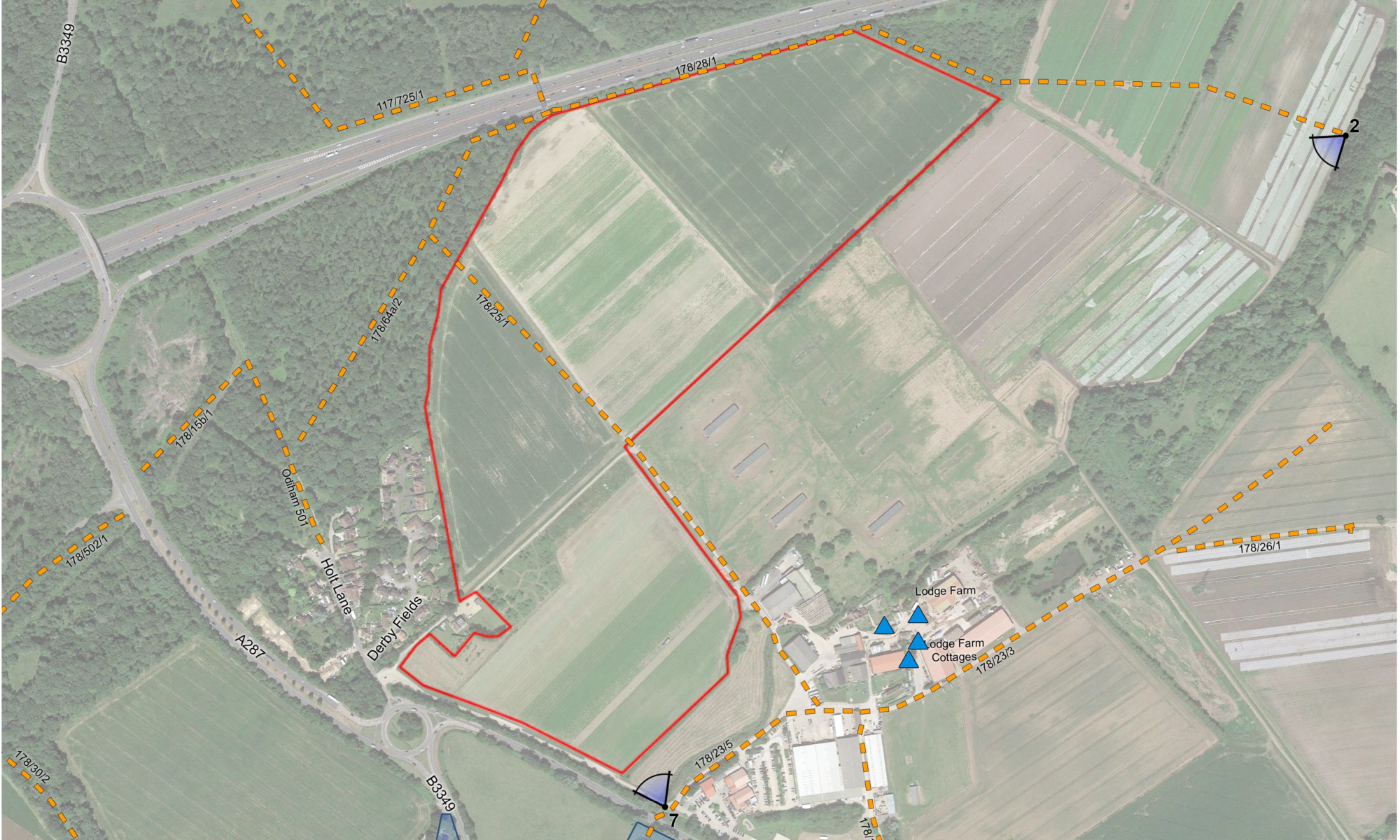
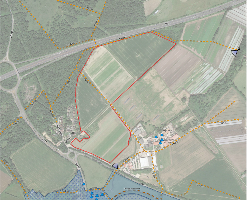
JBM Solar is proposing a photovoltaic solar farm on land at Bunkers Hill Farm. The proposal would cover approximately 200 acres of Grade 3b agricultural land and deliver up to 50MW renewable energy. The site runs alongside the River Whitewater, with solar panels for the next 35+ years. We encourage you to look at the developer’s website to see the location of this proposal, also shown on the map above.
This is one of four current proposals for large solar farms in the Whitewater Valley, and one of five in very close proximity in the vicinity of Hook, North-East Hampshire, all of similar size and capacity. Each of these three proposals is just below 50MW, because over that capacity, they would be designated as nationally significant infrastructure, which would require consent of the appropriate Secretary of State.
The site proposed is:
Green belt (currently grade 3b farmland) of approximately 71 Ha
The site is within the parish of Rotherwick and the location impacts the parishes of Mattingley, Hook and Hartley Wintney
The location is bounded approximately by Bartlett’s Farm to Hook allotments (North to South) and the B3349 to River Whitewater (West to East).
Landscape character and type
The Bunker’s Hill proposed development is located on a greenfield site, on the western valley sides of the Whitewater Valley, on gently undulating land.
As noted in Hart’s report on the EIA screening (20/01807/EIA) the site is within the Whitewater Valley Landscape Character Area. This proposal would introduce built development on a greenfield site over a significant area. The proposed development would change the visual appearance of the area and result in some impact upon the landscape.
Hart’s Landscape Character Assessment (1997) identifies the Whitewater Valley landscape character area as within the Open Arable Farmland landscape type. Hampshire’s Integrated Landscape character assessment (2010) classifies the site as falling within Lower Mosaic Open landscape type.
Rights of way
The site has a sloping topography and is part of the valley for the River Whitewater with varying degrees of visibility from Reading Road. There are three public rights of way (PRoW) that cross the site:
PRoW16 running north/south through the northern part of the site then past Barlett’s Farm;
PRoW17 running east/west through the central part of the site past Neville’s; and
PRoW23 running east/west across the southern part of the site south of Bunkers Hill Farm.
In particular, the Brenda Parker Way long distance route runs between Andover and Aldershot. This route connects Tylney Park with the river valley and West Green Conservation Area in the east.
Other footpaths provide circular routes from centres of population into and across the Whitewater Valley landscape.
The use and value of these routes increased dramatically in 2020-21 and has remained high with many residents now working from home.
Landscape and visual impact
Landscape impacts may be confined to the site, whilst visual impacts would be wider. Coverage of the site would be over a large area but at low level. These impacts would be reduced through the retention of landscape features such as trees and hedges, although any such mitigation measures would likely vary in effectiveness given seasonal changes in foliage.
Therefore it is important o fully assess impacts on landscape and visual amenity through a comprehensive Landscape and Visual Impact Assessment, particularly in relation to public views from the PRoWs.
Local communities value the recreational resource, which the river and valley provides. So it will be important that the Landscape and Visual Impact Assessment (LVIA) provides a comprehensive set of representative viewpoints. These include assessment of effects from other key features, such as heritage and nature conservation assets, particularly where they contribute to sense of place and special qualities of the river and landscape more widely.
The proposed development includes a number of features, which can give rise to landscape and visual effects, in addition to the photovoltaic arrays. Ancillary development, such as fencing and CCTV posts, can also have an urbanising influence on the landscape.
Deer fencing in an area heavily populated by deer and in a council named after the deer (Hart) is of particular concern.
The current proposed layout does not detail the position of inverters (other than the central inverter), CCTV poles, storage container(s), access arrangements, delivery station or the location of the construction compound.
We would expect the LVIA to consider the effects of all aspects of the proposed development. This includes during construction, operation and in relation to the potential for solar glare.
Local plan
Local Plan Policy NBE2 – Landscape is relevant to the proposed application. It states that ‘development must respect and wherever possible enhance the special characteristics, value and visual amenity of the District’s landscapes. This should be done with reference to the Hart District Landscape Character Assessment, visual amenity and scenic quality of the landscape and other identified criteria.’
There is increased recognition of the value of landscapes in terms of Local Plan Policy, local communities (as reflected in the Hook Neighbourhood Plan) and National Planning Policy (Para 170). Given this, we request that the LVIA includes a detailed assessment of landscape value of the Whitewater Valley, which will be affected by the proposed development.
Whitewater Valley Preservation Society response
The Whitewater Valley Preservation Society submitted its WVPS comments re Bunkers Hill Solar Farm objection to Hart District Council on the full application for a solar Farm at Bunkers Hill, Rotherwick, Hook RG27 9DA.
Our analysis of the application revealed that the applicant has failed to meet the pre-application advice provided. The applicant failed to provide thorough, rigorous assessments of the effects on Landscape, Public Rights of Way (PRoW), Heritage Assets and Ecological impact.
The Society’s thorough reviews of the developer’s assessments reveals the true extent of damage that would be caused by this proposal. The reviews also demonstrate that the application fails to comply with Hart’s policy requirements and, therefore, fails to satisfy the basis on which the application could be approved.
In conclusion, the Society believes this development would have a significantly negative impact on the Whitewater Valley. The development would destroy the valued landscape and historic assets / environment of the Whitewater Valley. This development – if approved – would change the rural nature of the Whitewater Valley and adversely affect the enjoyment of its landscape by this and future generations.
The Society’s members believe passionately in the integrity of this beautiful section of the Valley. They are distraught at the damage that would be caused to this idyllic and characteristic lowland river valley by what would be an extremely industrial intrusion of the proposed solar farm and its accompanying paraphernalia.
It is on this basis that the Whitewater Valley Preservation Society objects to the application. We therefore trust that Hart will refuse this application.
Background to the proposal
The full planning application – 21/00552/FUL Solar Farm and battery stations together with all associated works, equipment and necessary infrastructure – was registered on 8 March 2021. To view the application documents and submit your comments, please go online to Hart District Council planning applications , click on “View and comment on planning applications“, and enter 21/00552/FUL in the Search box. The deadline to submit comments to the public consultation was Wednesday, 7th April 2021.
JBM Solar conducted a limited consultation on their initial proposals in September 2020. This was publicised by posting leaflets to selected addresses in the Rotherwick area; and initially requested responses from residents within a few weeks. The Whitewater Valley Preservation Society requested that their publicity was extended to a much more appropriate, wider area and an extension to their deadline to Friday, 23rd October 2020. We submitted our response by the extended deadline. To request a full copy of our response, please email us.
A request for screening opinion – 20/01807/EIA – as to whether the solar farm planning application would require a full Environmental Impact Assessment, was submitted on 3 August 2020. Whilst a full EIA was not required, the report noted that:
Potential impacts on the River Whitewater (including those from accidents) would need to be fully assessed
Given the site area, flood risk zones and that the land immediately adjacent to the river such that the ground is at risk of groundwater flooding, any planning application would require a Flood Risk Assessment and drainage strategy.
There may be impacts upon the settings of heritage assets nearby. These include the Mattingley Green and Rotherwick conservation areas and a number of (Grade II and one II*) listed buildings in close proximity to the site boundary. Such impacts would need be considered in a Heritage Assessment.
JBM Solar is proposing a photovoltaic solar farm on land at Bunker’s Hill Farm. This is one of two current proposals for large solar farms in the Whitewater Valley, North-East Hampshire.
The proposal would cover approximately 200 acres of agricultural land. The site runs alongside the River Whitewater, with solar panels for the next 35 years +. We encourage you to look at the developer’s website to see the location of this proposal.
As a Society we are planning a proactive approach to this application to reflect our role as the voice of the valley. We will communicate our plans to you as soon as possible. In the short term, the developers are looking for responses, via the developer’s websiteby the now extended date of Friday, 23rd October at 5pm.
Whilst we will respond, as a Society, we would also urge you to email them, as an individual. Please encourage those who you believe have an interest in the valley, as residents, business owners, walkers, anglers or cyclists etc. to do so themselves.
Clearstone Energy is proposing to develop a 50 MegaWatt photovoltaic solar farm, adjacent to the headwaters of the River Whitewater in North-East Hampshire. The total site area is 143 hectares.
The site runs to the south east of Bidden Road and surrounds Chosley Farm. It extends south to meet Alton Road. It is positioned between North Warnborough to the north east; Odiham to the east; RAF Odiham to the south east; South Warnborough to the south; and Greywell to the west. The site is within the Hart Downs landscape character area. There are two public rights of way across it, and the Greywell Fen site of special scientific interest (SSSI) is located to the immediate north west of the site.
The applicant claims there is currently no intention to place panels on the land north west of the Bidden Road, not least as it forms the immediate valley side, facing broadly north.
This has been the subject of a pre-application (20/00180/PREAPP) consultation and an Environmental Impact Assessment screening opinion (20/01658/EIA). Hart District Council responded to the pre-application consultation on 1st May with considerations for the full application. The Whitewater Valley Preservation Society submitted comments on both the EIA screening opinion and pre-application raising the countryside and landscape impact of the proposal.
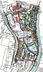
19/00543/FUL Albion Yard – Objection to proposal for development
Any development on this site must be sympathetic to the special nature of the environment, related as it is to sites of special scientific interest (SSSI).
The River Whitewater, a ‘Main River’, is a chalk stream, which is rare and important at international level. The River Whitewater flows north of the proposed development site in a north easterly direction. An unnamed tributary of the River Whitewater flows in an easterly direction through the land to the west of the site. It turns to follow a northerly route approximately 70m north west of the site. It discharges into the River Whitewater near Mill Corner. The River Whitewater is a Site of Interest to Nature Conservation (SINC) throughout its length and includes stretches of SSSI. The Basingstoke Canal, which is also a SSSI, is located along the southern boundary of the site.
According to the findings of the Environment Agency, the River is failing to meet ‘Good Ecological Status’ as required under the Water Framework Directive.
The Flood Risk Assessment provided for this proposed development is out of date, despite the propensity of the site for flooding. Flood risk resulting from the loss of land to absorb and channel waters from the River Whitewater flood plain requires very careful and partial use of the site for development, as indicated in the Neighbourhood Plan. In addition, surface run-off from building infrastructure on this site would flow into the River Whitewater, likely to affect further the ecological status of the River.
The principle of biodiversity enhancement in the adjacent field is welcome. However detailed input from a qualified ecologist is required to turn the proposed plan into practice that will deliver a net gain for biodiversity. This should be secured through a full Landscape and Ecological Management plan for the future, which includes a landscape buffer as indicated in the Odiham and North Warnborough Neighbourhood Plan.
The plans are not aligned with the Odiham and North Warnborough Neighbourhood Plan, which protects the setting of neighbouring listed properties by the provision of a significant open space at the North end of the field.
In summary, the proposed development affects the landscape characteristics of the North Warnborough Conservation area. The development as proposed does not adhere to the Odiham and North Warnborough Neighbourhood plan, specifically policies 2 iv, 7 and 12.
This is an update from Hook Action Against Over-development
Owen’s Farm, west of Hook
The Appeal for the 700 home development at Owen’s Farm to the west of Hook opened on 19th March. Hart District Council and residents stated their case to the Planning Inspector. Then, on day 4, the developer withdrew their appeal before even presenting their own case!
Hook Action Against Over-development, Parish Councils, Whitewater Valley Preservation Society and individual residents made their representations in writing and in person. The developer then realised what we already knew to be true. There was absolutely no justification for their application, let alone their appeal. So one might ask why did they even go to appeal against the refusal of planning permission if their case was so weak? They had attempted to hoodwink everyone that the plethora of issues with the application were resolved. They tried to push through their appeal before the Hart Local Plan and Hook Neighbourhood Plan had been adopted, which would formally block out this site for residential development. But we knew there were still significant issues and brought them all to the fore.
The developer made the withdrawal conditional on each party paying their own costs. Hart and the other participants fighting the appeal decided that this was acceptable. The costs incurred so far were worth swallowing in order to halt the proceedings there and then. Rather than extending the appeal, incurring more costs and risking an adverse result, even though we believed that their chances of success were slim. Given the massive imbalance of spending on the appeal, making them swallow their own costs and their failure to realise a return on their investment on the whole venture ensures that there was a big financial penalty to them withdrawing the appeal.
With the Hart Local Plan and the Hook Neighbourhood Plan at advanced stages now, another application for development on this site should not be feasible until at least 2032. The same access, transport and landscape issues are likely to apply then. So it would be a brave developer who would chance an application. There will be a review of progress on housing delivery in 4 or 5 years. If Hart are under-delivering it is possible the Plan may need to be revised, but we hope that even then this site would be unattractive for all the existing reasons.
The issue of the Common Land and Village Green applications still needs to be resolved. We have already written to the relevant department at the Planning Inspectorate pointing out that they are now not necessary because development here is not going ahead and therefore the applications should be refused, if they are not withdrawn first. We are following up on loose ends to try to protect against this development proposal returning.
Hook Neighbourhood Plan
The fact that the Hook Neighbourhood Plan had by the time of the Inquiry been submitted to Hart for formal review was a considerable factor in itself. The Neighbourhood Plan still needs to be formally adopted by a public vote, once reviewed by Hart. We need to get it formally adopted so that it has full planning weight as soon as possible.
Thank you
We have already received over a hundred messages of thanks by email and on Facebook. Whilst we are sorry we can not reply to everyone individually, we would like to say thank you to everyone for your support. It feels like Hook has been under assault for the past 5 years and of course major expansion of the village is already underway. Hopefully we can now pause for a breath and welcome the new residents who are coming into Hook to join us in making a life here. We know we are lucky to live here for all the practical reasons that make Hook a great place to live, for the proximity to the countryside that we have fought hard to protect, and of course mainly for the great people we have as friends and neighbours in the village.
With this being our biggest victory to date, on a personal note I would like to give a huge thanks to all those in HAAO who have worked tirelessly on the defence of Owen’s Farm and on the other battles we have both won (Hop Garden Road) and lost (North East Hook and others) over the last 5+ years. So thank you all.
This would also not have succeeded without everyone acting as a team. So thank you to the Parish Council and Neighbourhood Plan group for all their help and support. Not forgetting Whitewater Valley Preservation Society, Newnham Parish Council and of course, all the residents of Hook and Newnham who planned and carried out surveys, leafleting, posters, banners and publicity. We also want to thank everyone who worked on the previous successfully defended Hop Garden Road refusal, including the Planning Inspector then, Mr Schofield, who accepted that the local gap to Newnham was of considerable value to both villages. His decision then underpinned our case this time too. Thank you to the Hart planning team who worked with us on this case, the Hart councillors who finally pushed through a Local Plan to a stage where it can help defend against speculative development. Also to Basingstoke and Deane for having a Local Plan in place covering Newnham.
Finally thank you and good luck to those other groups from across Hart who have joined with us while fighting their own battles against urban extensions. Many other people have provided direct and indirect help to us, thank you all.
The following is an update from the Chairman of Winchfield Action Group on the Inspector’s examination of Hart’s Local Plan
Dear Supporters
The Inspector, Jonathan Manning, has written to Hart Council. His letter comes in advance of his full Inspection Report, which is due in the next few weeks. In it, the Inspectors instructs Hart to remove the New Settlement at Winchfield/Murrell Green from the Local Plan. The reason given is that a New Settlement is not required to meet the housing need. This is very good news. The full letter (called EXAM 60) is available here.
Hart District Council remains determined to develop new settlement
However, in announcing this news at the Council Meeting on Thursday, Councillor Cockarill (Planning) said that “The important point here is that the Inspector does not rule out a new settlement option in the future. He recognises our clear aspiration to deliver a settlement to meet our long-term housing needs. He accepts that it would be acceptable for the Plan to retain the Council’s aspirations to plan for long term needs beyond the plan period which could refer to the delivery of a new settlement through potentially either an early or immediate review of the Plan or a subsequent Development Plan Document (DPD).”
In other words the threat of an unnecessary New Settlement has not gone away, and the Council seems as determined as ever to develop a new settlement as soon as possible, as a way to block the regeneration of Fleet and the other urban centres.
Next steps
In the next phase of our campaign we therefore need to make a convincing case that:
a) the most urgent need for Hart is to regenerate its town centres (especially Fleet). Thus reversing the commercial decline of the whole district.
b) the regeneration of Fleet and the other town centres with mixed-use (residential, retail and leisure) developments has the potential to deliver enough new housing. This obviates the need for any major greenfield developments in the foreseeable future.
And it is not enough to make this case to the Council. We have to convince the general public. Fleet and the other urban centres can accommodate the bulk of the new housing requirement, whilst at the same time becoming more attractive places to live and work.
We need to study the Inspector’s Full Report, once it is available, to see what detailed changes he has recommended to the Local Plan. We will look particularly for policies on Town Centre development (ED5). Once we have done this we will be able to formulate a plan of action to protect our countryside and rural villages.
We have taken an important step forward today. Thank you as always for your support.
The Whitewater Valley Preservation Society registers its objection on behalf of our members to the above application. The Society believes the proposed development would have a detrimental impact upon the Whitewater Valley and would damage the rural character of the valley.
We wish to identify the risks to the River Whitewater from water courses, including a tributary of the River Whitewater which crosses the site, which run into the Whitewater and are already subject to flooding.
Conservation Areas, SSSI and SINC
The development as proposed would adversely affect two Conservation Areas – those of North Warnborough & Basingstoke Canal – and a Site of Special Scientific Interest (SSSI), the Basingstoke Canal.
The proposed development raises issues regarding the rich biodiversity and ecology of the SSSI and the historic landscape, contrary to the National Planning Policy Framework (NPPF) paragraph 109. As required by the Environment Agency and the Ecological Appraisal provided, a 10m buffer zone – which is free from lighting and domestic gardens and landscaping – must be implemented. The Society objects to a link road between the two halves of the site, which intrudes on what should be an undeveloped buffer zone, and is a footpath in the neighbourhood plan.
The Society also objects to the proposed layout, which would develop a suggested undeveloped area identified in the Odiham & North Warnborough Neighbourhood Plan, which would help preserve important views across the site from the Basingstoke Canal.
The River Whitewater is an identified Site of Interest for Nature Conservation (SINC) and is already failing to meet Good Ecological Status (GES) as identified by successive Riverfly Censuses commissioned by the Society. As GES is required to be met under the Water Framework Directive, there is a real concern that additional pollution will inevitably result if the application as proposed were to proceed in addition to already granted development at the Chilli Pad and being sought to the rear of Castle Bridge cottages. The GES status is not recorded when considering Water Quality in the Flood Risk Assessment and Drainage Statement.
Flood risk
Neighbouring residents have submitted copious evidence and case studies, which demonstrate the existing surface flood risk experienced regularly on this site and surrounding lower elevation sites adjacent which include many listed buildings. These flood events are not recorded in the Historical Flooding report in the Flood Risk Assessment and Drainage Statement provided by the developer.
Moreover, this development raises issues regarding the structural integrity of the Canal, which can only further increase the risk of major flooding events on a site that is lower than the canal and undercuts its 225 year old structure.
Climate change will further increase the flood risk as we expect more frequent and severe storm events. The Environment Agency guidance recommends +70% for peak riverflow allowances for the Thames River Basin, in which the River Whitewater is situated, over the lifetime of the development.
Conclusion
The Flood Risk Assessment and Drainage Statement provided by the applicant is inadequate for a sensitive site in the flood plain of the River Whitewater.
All the above matters and environmental impacts are exacerbated by the applicant continuing to propose substantially more houses for the site than the Odiham & North Warnborough Neighbourhood Plan proposed.
Further information
Please see the attached leaflet, produced by local residents.
WVPS supported the Rural Hart Association in opposing the proposal from Hart District to include in the new Local Plan a “New settlement” in the Winchfield/Murrell Green area. Murrell Green sits on the River Whitewater.
This is a report on the Examination of Hart’s Local Plan from Tristram Cary of the Rural Hart Association
Dear Supporters
The 10 day Examination-in-Public of the Local Plan finished just before Christmas, and the Inspector, Jonathan Manning, is now writing up his report which is due to be delivered to Hart sometime in February.
It is hard to predict what the Inspector’s report will recommend, because he made a point of digging into the evidence without drawing conclusions – and he warned us all several times NOT to jump to conclusions based on his line of questioning. However, on balance we think the Examination went well from the point of view of the Winchfield Action Group and the Rural Heart Association. Below are some of the key points that have a bearing on the New Settlement and Green Field development generally:
General
The Inspector, Jonathan Manning, was very thorough and fair. He had done his homework, and was quick to detect flannel and to insist on accurate answers to his questions. But he also found time to let everyone have their say. I think we can be confident of a fair report. The Rural Hart Association was invited to participate in Matter 3 (Housing: The Objectively Assessed Need), Matter 4 (Housing: Spatial Distribution) and Matter 10 (Retail and Town Centres). RHA was represented by Mark Dodds (Director of Planning and Development at Lambert Smith Hampton) and me. Winchfield Parish Council and their consultants were invited to participate in most of the twelve Matters, so between us we were able to represent the interests of rural Hart across the whole spectrum of the Local Plan.
Matter 1: Legal Requirements
The Inspector pushed Hart hard to demonstrate that their Sustainability Appraisal was adequate to justify the Local Plan and, in particular, the choice of Murrell Green/Winchfield over alternative sites for a New Settlement. The Inspector did not seem to be impressed with Hart’s response, and if he finds the Sustainability Assessment unsatisfactory then this is likely to lead to a recommendation for significant changes to the Local Plan (see conclusions below), or a significant delay while the Sustainability Appraisal is re-worked.
Matter 3: Housing Numbers
There was a fairly even split between those who want the housing numbers to be higher (mostly the developers) and those who want them to be lower (those who oppose building on greenfield sites and want to keep Hart rural). It’s hard to predict what the Inspector will recommend, but probably not a substantial change to Hart’s recommendation of 388 new dwellings per annum for the plan period.
Matter 4: Spatial Distribution of Housing
This was a key session where Hart’s decision to commit to a New Settlement in Winchfield/Murrell Green came under severe pressure from the Inspector who asked how Hart could possibly commit to a specific site when there was no satisfactory evidence that the plan was ‘deliverable’ or that the site was better than any alternative site. Hart’s defence was basically that the New Settlement strategy (SS3) was not yet a plan for a New Settlement, but just a strategy to find a New Settlement within the Winchfield/Murrell Green area of search. But this seemed to cut no ice with the Inspector who said that if there was as yet no site for the New Settlement then it was even less possible for Hart to know that it was a better site than any of the alternatives.
Matter 10: Retail and Town Centres
In this session we (RHA) were able to make our case that the regeneration of Fleet and the other urban areas with mixed-use (residential, retail and leisure) developments could provide a significant number of new houses (over 1000 in Fleet Town Centre) and at the same time reverse the long-term decline of Fleet as a vibrant and commercially-successful town centre (a trend which Hart acknowledges in the Local Plan). We were further able to demonstrate that such mixed-use developments could attract private investment (based on the response of developers to RHA’s plan to regenerate the Hart Shopping centre). And finally we stressed that Hart’s premature committment to a New Settlement was a barrier to the regeneration of Fleet (because developers are reluctant to invest in regeneration schemes which are not actively promoted by the Council in the Local Plan). I am sorry to say that the Inspector did not grill Hart very hard about their failure to provide a convincing plan to regenerate Fleet or the other urban centres. Nor did he clearly acknowledge that the plan for a New Settlement (which is not needed in the Plan Period) would be a barrier to regenerating Fleet (which Hart accepts is needed in the Plan Period). However, he did challenge Hart to justify why their policy to regenerate Fleet was so short on substance, and why it excluded the possibility of residential development. And he also asked Hart to include the consideration of residential development in the plan for Fleet (ED5).
Matter 11: Infrastructure
The Infrastructure session was important for RHA’s cause because the Inspector questioned whether Hart’s Infrastructure Development Plan demonstrated a sound understanding of the infrastructure costs of the Plan, and in particular the plan for a New Settlement in the Winchfield/ Murrell Green area of search. Hart had to fall back again on the mitigation that the infrastructure costs of SS3 could not be known at this stage because the site of the New Settlement was still unknown within the area of search. This allowed the Inspector to ask again how, if the infrastructure costs were unknown, Hart could know whether a New Settlement in the Winchfield/Murrell Green area was a better proposition then the alternatives.
Conclusions
We have been warned by the Inspector not to try to predict the recommendations that he will make in his report and so we will not do so. However, based on our discussions with Lambert Smith Hampton and the other attendees, we think the following notes are relevant:
The Inspector clearly feels that SS3 is too prescriptive (when the quality of supporting evidence is so poor). So his recommendations are likely to soften the categorical nature of SS3 (“Permission will be granted for a New Settlement in the Winchfield/Murrell Green area of search” etc).
The Inspector is also concerned that the plan for Fleet is not ‘positively prepared’ and does not include any provision for residential development. It is possible that the Inspector will recommend that a proper ‘Masterplan’ for Fleet should be developed as a high priority, so that the potential of Fleet for residential development can be assessed before (or at least in parallel with) planning for a New Settlement
The Inspector asked Hart at several points in the Examination whether it would be practical to delay the decision to embark on a New Settlement until the first review of the Local Plan at the five year point (c. 2024) or even, if necessary, to bring forward the review by a couple of years to say 2022. Based on the Inspector’s serious concerns about the quality of the evidence justifying a New Settlement in the Winchfield/Murrell Green area, it seems possible that the Inspector may recommend that any commitment to a New Settlement should be removed from the Plan at this stage, and reviewed after a few years.
A delay to the decision about the New Settlement for a few years may not sound like much of a result, but it would be a significant step forward, especially if the delay was linked to a requirement to assess the regeneration of Fleet (and the other urban centres) as an alternative source of new housing. A delay would also put pressure on Hart and Fleet Town Council to accept the growing realisation across the UK that mixed-use redevelopment of Town Centres is the best way to reverse their decline.
We must now wait and see what the Inspector’s report recommends. But in the meantime, Fleet Town Council’s plan to build a new Theatre complex on Gurkha Square (to replace the Harlington Centre) has been withdrawn as a result of Fleet residents’ strong objection to funding the theatre out of Council Tax for the next thirty or forty years. This represents a good opportunity for Fleet residents to a) put pressure on Hart and Fleet Town Council to recognise that developers are prepared to fund leisure facilities as part of a mixed-use residential development and b) to encourage the Council to back the scheme to redevelop the Hart Shopping Centre (which includes a commercial cinema).
I am very grateful for the generous contributions that so many of you have made towards the Design Study for the Regeneration of Fleet. A summary of the Design Study is here, but please let me know if you want to see the full report – it’s too bid to attach to this email without causing a lot of delivery failures. The Design Study has demonstrated convincingly that Fleet can be regenerated without taxpayers support with mixed-use developments which would provide additional affordable homes, improved retail facilities, extra public spaces and leisure facilities. Furthermore, Lambert Smith Hampton has now had two expressions of interest from developers who would like to invest in the proposal, but only if Hart’s Local Plan is modified to express a commitment to working with developers to bring forward such a scheme.

 < Before After >