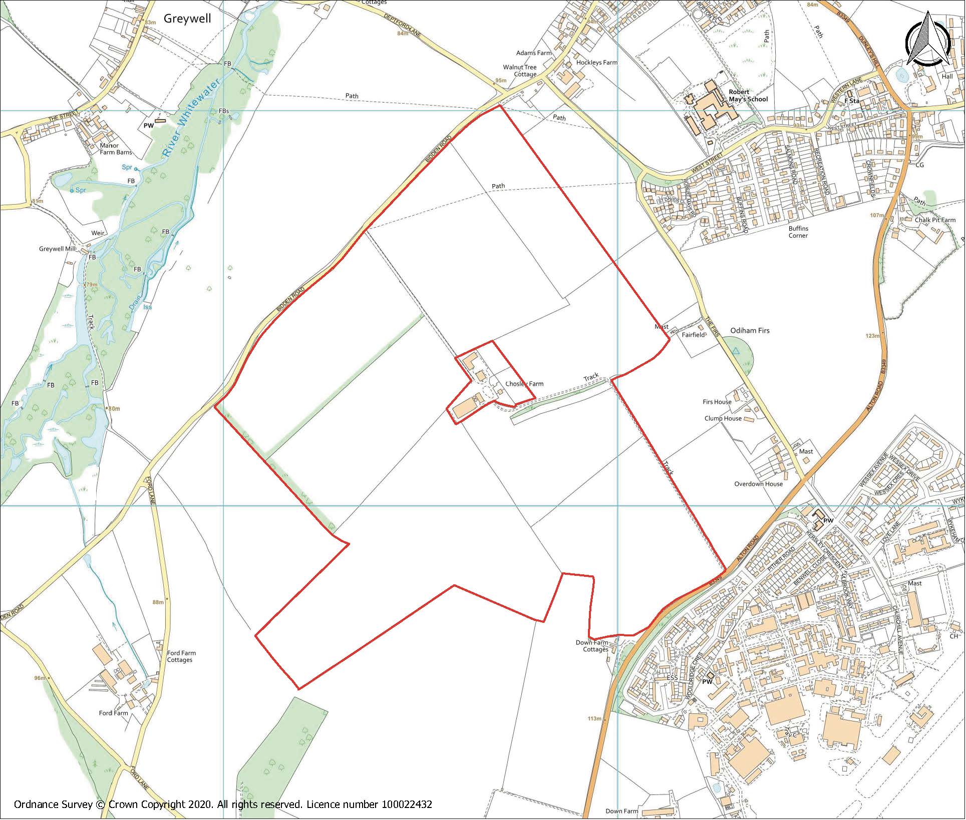
20/031835/FUL Chosley Farm Solar Park, Bidden Road, North Warnborough
Whitewater Valley Preservation Society response
Introduction
The Whitewater Valley Preservation Society was formed in 1980 with the specific aim of fighting unacceptable development proposals which founder members felt posed a significant threat to the health of the valley and the river.
The Society has set itself the objective of trying to protect the Whitewater Valley and the river from its source at Bidden to its confluence with the Blackwater, representing approximately nine miles of chalk stream. We represent some 200 riparian owners, residents and supporters of the Valley.
WVPS Objection
The National Planning Policy Framework (NPPF) paragraph 170b requires the classification of the agricultural land to be considered. NPPF clearly identifies the unsuitability of agricultural land that is higher than 3b for the siting for a solar farm. The Agricultural Quality Survey shows that the Chosley Farm proposal is on high quality agricultural land, with 51% categorised as Grade 3a, the “best and most versatile” agricultural land, which should not be prioritised for this development. If one considers the situation from an ecosystems services and natural capital assessment this site will surely fail.
HLP32 policy NBE2 states clearly that any adverse impact upon landscape and scenic quality and visual amenity must guide any principles of development.
The following assessment identifies the true extent of the impact upon all of these issues and one must not forget that the pre application advice stated that landscape was the key to whether this application could be approved or refused.
The applicant incorrectly claims that the chosen site is ideal with its dome shape because they consider that gives the site limited visibility. Whereas landscape features, landscape character and visual affects are all detrimentally impacted as a result of choosing a site located only a few metres from the well-known signal station site The Firs.
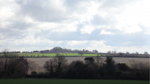
As a consequence not only will the significance of the Firs be degraded by the proximity of 95.47 Ha of dark reflective material and superstructure together with 3m hedging. The applicant’s own material indicates the 360° angle from which the site will be viewed from adjacent roads, major and minor, footpaths and bridleways but ignores the fact that due to the topography of the site it is visible for miles around and sufficiently far afield to be easily visible from such villages as Greywell, South Warnborough, and Upton Grey.
The site is adjacent to the SSSI at Greywell Fen and the northern half of the site is contained within the upper slopes of the Whitewater Valley, in one of the few places along the length of the river where the valley is pronounced and a visible and important part of the landscape. The photographs in below demonstrate that the longer range views and the landscape character will all be afflicted and adversely affected by the presence of the dark reflective panels and the way that the long views beyond the valley will be hidden by the proposed high planting needed to obscure the view of the solar farm, which will change the character of the landscape. The photographs illustrate clearly that the attempt by the applicant to claim that the landscape around this site has already been degraded by the RAF station is inaccurate, which in fact is invisible apart from the odd aerial, whereas the urbanising effect of the proposed installation will utterly destroy this altogether rural landscape.
Landscape character
The main distinguishing features in the National Character Area profile are “the rolling elevated chalk arable downland has an open, exposed character that provides open skies and long-distance views” and in the Hart District Character Area assessment “typical chalk scenery with strongly rolling land forms, sooth hill tops and dry valleys. A dominance of intensive arable cultivation and weak hedgerow structure, shallower slopes at the edge of the chalk which creates a large-scale, predominantly open landscape with extensive views and a sense of exposure.”
The applicant claims the proposal would have a Neutral or Minor Beneficial impact on a landscape which is described as having weak hedgerow structure by planting very high hedges which will obscure the long views for which this landscape is recognised. There must be a question of confidence that a new chalk grassland can be achieved, given the proposed structures on site and management regime. Therefore the impact upon the landscape character must be regarded as Adverse.
Visual impact
A detailed assessment of the total visual effect upon the North Downs can only conclude a sufficiently adverse impact as to require, on its own, that the application be refused. Whilst the applicant claims to be able to turn Major and Moderate Adverse into Negligible Adverse or Neutral this is achieved by ignoring the 360° visual impact upon the landscape which will be viewed from the many roads, byways and public rights of way and in particular will impact upon the valley identified in the Hart District Landscape Assessment. Just downstream of the source at Bidden, the valley at Greywell is at its most discernible and should not be disrupted by the solid black and reflective insertion of 95.47 Ha of solar panels. Furthermore raising one’s eyes from the view across the valley (for example from many points in Greywell) the RAF station is nowhere to be seen, but the distant hills to the south reveal the extent of the long views and why the North Downs are so valued.
River Whitewater / Greywell Fen SSSI
The proposed site is in the Whitewater Valley running right up to the source of the river Whitewater at Bidden Farm. The River Whitewater is a rare and important chalkstream environment, one of only around 200 hundred chalk streams globally, which combined with its proximity to the Greywell Fen SSSI, makes the location particularly inappropriate.
Greywell Fen is Grade 1 SSSI (Nature Conservation Review, NCR site). The main part of the site consists of waterlogged alkaline peats, flanked by a chalk valley. It has large areas of grazed fen meadow and tall fen vegetation, including reed beds.
According to the findings of the Environment Agency, the River Whitewater is currently failing to meet ‘Good Ecological Status’ as required under the Water Framework Directive. This conclusion is supported by three years of Riverfly surveys commissioned by the Whitewater Valley Preservation Society, with Salmon & Trout Conservation.
Natural England considers that the application could have potential significant effects on the Greywell Fen SSSI, particularly through construction impacts (e.g. from dust, spillages, polluted runoff etc) and discharges to the protected fen, wetland and river habitats.
In order to mitigate these adverse effects and make the development acceptable, Natural England requires that a drainage design should be submitted and agreed with Hart District Council. This should include evidence to show that the proposals will ensure there will be no deterioration in water quality, or changes to water quantity, in discharges from the site. This has not been provided with the application.
Basingstoke Canal SSSI
The Basingstoke Canal, together with associated ‘flashes’ and heathland, is nationally important for aquatic plants and invertebrates. The transition from calcareous spring water to slightly acidic conditions produces an extremely diverse flora, containing approximately half (87) of Britain’s native aquatic higher plant species, including 5 nationally scarce species. The Basingstoke Canal is botanically the most species-rich aquatic system in England. Twenty-four species of dragonfly occur on the Canal and other insects, including two nationally rare (Red Data Book) species, are well represented. Two sections of the Basingstoke Canal are of SSSI status. The western section lies between Greywell in Hampshire and Hermitage Bridge in Surrey.
The relative lack of pollution in the canal and the variation in water chemistry throughout its length have given rise to a diversity of plant species and communities that has no parallel elsewhere in Britain. This together with a rich and varied invertebrate fauna makes Basingstoke now a waterway of exceptional value to nature conservation:
The canal is largely supplied by calcerous water from Springs situated at the junction of the chalk and Reading beds (clay) at Greywell. Due to a slight West-East gradient, which gives rise to a definitive water movement, the overall system is an analogous to a slow flowing River with initially alkaline water which gradually becomes more acidic and less charged with calcium. Such a combination is a rare feature in Britain.
The vegetation types reflect this gradual change in water chemistry. At Greywell the flora is typical of that of a nutrient-rich southern chalk stream.
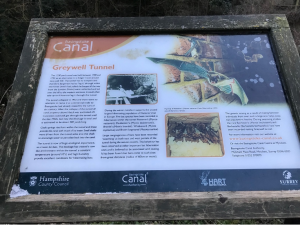
Greywell Tunnel information board
The Greywell Tunnel is of huge ecological importance as a haven for bats. The blockage has created a cave like environment within the tunnel, a constant temperature around 10°C and a high humidity provide excellent conditions for hibernating bats.
During the winter months it supports the second largest hibernating population of Natterer’s bat in Europe. Five bat species have been recorded in hibernation within the tunnel – Natterer’s (Myotis nattereri), Daubenton’s (Myotis mystacinus), Whiskered (Myotis mystacinus) and Brown long-eared (Plecotus auratus).
Large congregations of bats have been recorded swarming at both East and West portals of the tunnel during the autumn months. This behaviour has been observed at other important bat hibernation sites and is believed to be associated with mating. It has been found that bats come to such sites from great distances – radius of 60km or more. The genetic mixing as a result of mating between individuals from over such a large area helps keep bat populations healthy. During swarming studies the rare Bechstein’s (Myotis bechsteinii) and Barbastelle (Barbastella barbastellus) bats have been recorded visiting Greywell tunnel.
Natural England have commented that there is particular potential for adverse effects on the Greywell Tunnel (Basingstoke Canal) SSSI as the development would potentially impact on commuting and foraging routes for bat species utilising the tunnel for roosting. This comment was made elsewhere (Natural England review[i] of evidence of the impact of solar farms on birds, bats and general ecology and the EIA screening for the solar farm at Long Sutton) – but not on this application, which is much nearer and in the same valley as the Basingstoke Canal at Greywell Tunnel.
The Biodiversity Net Gain report produced by Weddle Landscape Design is misleading as it refers only to the claimed biodiversity “net gain” calculated via Natural England’s much criticised algorithm[ii] on the site itself. As outlined above, the important SSSIs of Greywell Fen, Basingstoke Canal and the River Whitewater are where the biodiversity and ecological impacts of this proposal will be felt.
Flood Risk Assessment / Drainage strategy
The Flood and Water Management team of Hampshire County Council, as the Lead Local Flood Authority, points out that the application contains no information about the proposed impermeable areas, discharge rates and volumes, so it fails to describe the real impact of the development on surface water management and local flood risk.
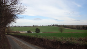
The picture below shows the almost permanently present “pond” opposite Ford Farm, showing where surface water drains off the solar farm site across Bidden Road and flows into the River Whitewater at/near its source. The presence of a major surface water overland flow route crossing the site and the need to robustly assess this as part of any future planning application is noted in the EIA screening.
Natural England states that drainage from the site could lead to deterioration in water quality, changes to water quantity in discharges from the site. Given that both the River Whitewater and the Basingstoke Canal SSSIs are designated for their unique water quality and chemistry this implies that surface water discharge could impact on these protected features.
Archaeology
Chosley Farm is the site of an important Romano British archaeological site as identified by the below ground archaeological section of the submitted Heritage Desk Based Assessment. The assessment demonstrates that there are a number of archaeological sites within the application area and that the site has a high potential to contain as yet unrecorded archaeological sites for the prehistoric periods through to the Roman period.
The impacts of the development such as roads, compounds, fencing and service trenches will have an archaeological effect (para 4.19). The assessment suggests that a staged approach to the mitigation is appropriate from targeted preliminary survey to mitigation, including mitigation by avoidance (ie preservation insitu) (para 5.7 to 5.11).
Application Process & Content
Hart District Council, as the Local Planning Authority, decided that an EIA was not required for this development, whereas they have decided that an EIA is required for a very similar size and scale of proposed solar farm development nearby to the south side of RAF Odiham.
There are inconsistencies between the submissions of consultees and opinions on whether an EIA is required, detailed in the Appendix 2, concluding:
| 20/01658/EIA Chosley Farm, North Warnborough |
20/02632/EIA Ford Farm, Long Sutton |
|
| Location | The site is not environmentally sensitive such that significant environmental impacts are anticipated. | The site is therefore considered to be environmentally sensitive such that significant environmental impacts cannot be ruled out. |
| Types and Characteristics of the Potential Impacts | The characteristics of the proposed development are not such that significant environmental impacts are anticipated. | The characteristics of the potential impact, given the spatial extent of the development, the nature of the impact in visual terms, the certainty of the impact and the duration of the impact (a minimum of 40 years), are such that significant environmental impacts are anticipated. |
The Planning Design & Access Statement provided by the Applicant is incorrect in a number of ways, including:
- It identifies the River Whitewater as the River Blackwater, which is 11 miles away.
- It identifies the Greywell Fen SSSI but fails to identify the Basingstoke Canal SSSI or the SSSIs that exist along the River Whitewater, which is also a SINC for its entire length.
This has a domino effect of errors and omissions on material impacts throughout the application and consultation, such that Natural England’s advice and the Applicant’s Landscape & Ecological Plan are incorrect and incomplete. These identify the Greywell Fen SSSI but fails to identify the Basingstoke Canal SSSI or the SSSIs that exist along the River Whitewater.
Summary
The landscape and visual impact, the ecological and water quality impact on SSSI protected sites and the archeological importance of the site combined provide reason to avoid irreversible land use change on this site.
For all of the reasons in the foregoing, WVPS wishes to register the strongest possible objection to this application and requests that it be refused.
The Whitewater Valley Preservation Society has submitted its latest response to amended information submitted by the potential developer of Chosley Farm Solar Park, Bidden Road, North Warnborough. Please find this here: Chosley Farm amendments objection.
[i] Natural England. Evidence review of the impact of solar farms on birds, bats and general ecology (NEER012) 1st edition – 9th March 2017 http://publications.naturalengland.org.uk/file/6000213410447360
[ii] https://www.endsreport.com/article/1675423/why-natural-englands-net-gain-calculator-may-struggle-accurately-value-nature
Comments
One response to “Chosley Farm Solar Park”
I totally oppose this solar farm proposal, it will have a detrimental impact on the Whitewater river, which is one of the worlds rare chalk streams/rivers and all the wildlife that it supports, it will seriously impact the bats that roost in the Basingstoke Canal tunnel, this again is such an important site, so much so it was mentioned on Winterwatch by Chris Packham. I drive along the Bidden Road every day and some nights and know for a fact, there are large herds of deer that roam the fields of the proposed solar site, there are Barn Owl roosts, herons that feed nearby, skylarks which are endangered, to name but a few. Surely a better more sustainable way could be found for sitting these panels, for example on the rooftops of offices/warehouses/shops and residential, or on the embankments of motorways and rail lines. The UK and the world should be protecting our green spaces in this alarming time of climate change.